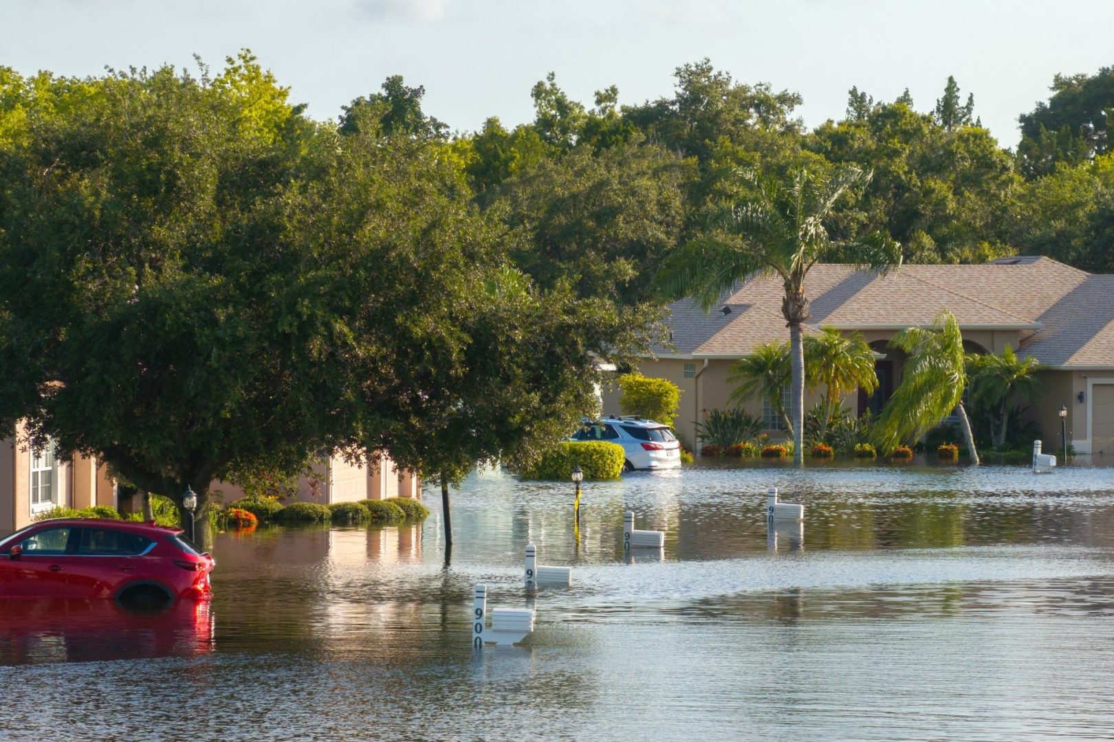
A powerful weather system unleashed torrential rainfall across New York’s Finger Lakes region Tuesday night, creating dangerous flooding conditions that closed roads and prompted urgent warnings from local officials.
The deluge transformed normally peaceful streams into raging waterways, overwhelmed drainage systems in urban areas, and rendered numerous roads impassable as the region endured one of its most significant rain events of the season.
Multiple counties under flood alerts
The flooding situation has affected seven counties across Central New York and the Finger Lakes, with varying levels of severity. The National Weather Service issued a patchwork of flood warnings and watches covering:
- Cayuga County
- Seneca County
- Yates County
- Onondaga County
- Madison County
- Cortland County
- Southern portions of neighboring counties
Areas under flood warnings experienced the most immediate threats, with actively rising water in streams, creeks, and roadways. By Tuesday evening, rainfall totals had already exceeded two inches in multiple locations, with some isolated areas reporting even higher amounts.
The areas under flood watches remain at elevated risk as the saturated ground struggles to absorb additional rainfall. Emergency management officials continue monitoring river gauges and weather radar to track the evolving situation.
Critical infrastructure impacts
The flooding has significantly disrupted transportation networks throughout the region. In Cayuga County, authorities were forced to close State Route 38A between Dewitt Road and Sayles Corners Road due to dangerous water levels overtaking the roadway.
The Cayuga County Sheriff’s Office emphasized the severe hazards posed by attempted crossings of flooded roads. Their warnings highlighted two specific dangers often overlooked by drivers: potential culvert damage hidden beneath floodwaters and the surprising force of relatively shallow but fast-moving water.
Navigation became particularly treacherous in King Ferry and across southern Cayuga County, where numerous secondary roads became completely impassable. Law enforcement reported that many rural routes were compromised by rushing water that concealed dangerous washouts beneath the surface.
Night conditions amplify dangers
Officials expressed heightened concern about flooding risks after sunset, when darkness makes it nearly impossible for drivers to accurately judge water depth or detect roadway damage. Even familiar roads can become deadly hazards when compromised by flood conditions that aren’t visible until it’s too late.
Emergency responders emphasized that most flood-related fatalities occur in vehicles when drivers attempt to navigate water-covered roadways. What appears to be shallow standing water can conceal complete road washouts or generate enough force to sweep vehicles downstream.
The National Weather Service repeated its life-saving advice: “Turn around, don’t drown.” They noted that just 12 inches of rushing water can carry away most passenger vehicles, while only 6 inches can knock adults off their feet in strong currents.
Weather system evolution
The flooding resulted from a slow-moving low-pressure system gradually lifting northeast through the region. This weather pattern created the perfect conditions for sustained heavy rainfall, as opposed to brief but intense downpours associated with faster-moving frontal systems.
Tuesday’s weather featured both thunderstorms with intense rainfall rates and periods of steady, moderate precipitation that continuously saturated the ground. By nightfall, the thunderstorm threat diminished somewhat, but widespread rainfall continued.
“The main threat transitions to steady rainfall overnight, with lingering showers across the Finger Lakes into Wednesday,” the National Weather Service explained in its Tuesday night forecast discussion. “Some localized areas could still pick up another inch of rain.”
This additional precipitation falling on already saturated ground creates heightened concern for flash flooding, particularly in areas with poor drainage or along waterways that have already reached their banks.
Forecast for coming days
Residents can expect some gradual improvement in conditions as the weather system evolves. By Wednesday afternoon, precipitation patterns will transition to more scattered showers rather than widespread rainfall, offering some relief to water-logged areas.
The approaching cold front will bring noticeably cooler air to the region. High temperatures on Wednesday will reach only into the 60s to lower 70s before dropping further on Thursday, when many areas will struggle to rise above the 50s.
Overnight lows will feel decidedly autumn-like, dipping into the 40s across most locations by late week. This cooler air mass will help stabilize the atmosphere and reduce precipitation chances temporarily.
However, the respite may prove brief. Weather models suggest another upper-level disturbance could approach from the west by Friday, potentially bringing a second round of rainfall to the region. The intensity of this system remains uncertain, but forecasters are monitoring its development closely.
Emergency response coordination
County emergency management agencies have activated their flood response protocols, coordinating with local fire departments, law enforcement, and highway departments to address immediate threats to public safety.
Some agencies deployed high-water rescue vehicles to strategically positioned staging areas, enabling rapid response to stranded motorists or residents threatened by rising water. Swift water rescue teams remained on heightened alert throughout the evening.
Emergency management officials continue monitoring river and stream levels, particularly at locations with histories of flooding during similar rainfall events. Special attention focuses on areas where development has increased runoff potential or where previous flooding has compromised natural drainage systems.
Resident preparedness advised
Authorities encourage residents in flood-prone areas to maintain vigilance for rapidly changing conditions. Those living near waterways should be prepared to move to higher ground quickly if water levels rise, particularly overnight when flooding can develop with little visible warning.
Emergency management agencies recommend keeping emergency kits accessible, including flashlights, batteries, emergency food and water, and necessary medications. For those in areas with histories of severe flooding, temporary relocation to friends or family on higher ground serves as a prudent precaution.
Residents should monitor local media, weather radio, or emergency alert systems for updated information about road closures, flood warnings, or evacuation notices. Many counties offer text-based alert systems that provide immediate notifications about developing hazards.
The combination of saturated ground, continuing rainfall, and numerous waterways throughout the region creates an ongoing threat that requires public awareness and caution until drier conditions finally arrive later in the week.